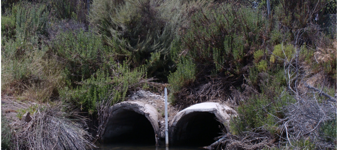
Famosa Slough Culvert Replacement: Design and Engineering

In 1993 The Friends of Famosa Slough and the Coastal Conservancy published the Famosa Slough Enhancement Plan. The Enhancement Plan included assessments of the Slough’s hydrology, freshwater, sediment, and nutrient inputs, and visitor-serving needs such as trails and facilities. One of the top priorities identified in the Enhancement Plan was to reactivate an inoperable culvert … Continued

Los Penasquitos Lagoon Restoration Design and Feasibility Study

Once a pristine coastal estuary with extensive salt flat and salt marsh, Los Peñasquitos Lagoon has lost over half of its historic habitats as a result of human activities and land-use change.  It is a 574-acre coastal estuary located in coastal north San Diego County, within the City of San Diego.  The Lagoon is a … Continued

Topanga Lagoon Restoration Planning Phase 1

The Topanga Lagoon Restoration Planning Project will advance the long-term planning effort for the restoration of Topanga Lagoon. Steelhead in the Santa Monica Bay are on the brink of extinction and Topanga Creek is the only stream with a reproducing population. However, the conditions in Topanga Lagoon are not optimal to support growth and rearing … Continued

Trancas Creek Flood Control Channel Restoration Planning Project

The Trancas Creek Watershed (8.7 square miles) is a small coastal creek draining into the western end of the Santa Monica Bay. Prior to the Woolsey Fire (2018), Trancas Creek had good to excellent spawning and rearing habitat for endangered southern steelhead trout (Oncorhynchus mykiss) and has been identified as a priority for restoration by … Continued

Trancas Creek Lagoon Restoration Planning Project

Trancas Lagoon is currently a seven-acre lagoon at the terminus of Trancas Creek in Malibu. In the lagoon, the creek flows through a modified channel, with riprap on the west bank and fill material vegetated with a mixture of wetland, riparian and non-native species. Historic maps and photos of Trancas Lagoon show that the lagoon … Continued

Goat Canyon Enhancement Project, Final Design Plans

This project prepared final design and engineering plans and conducted environmental review for the Goat Canyon Enhancement Project. The Goat Canyon watershed crosses the U.S./Mexico border near the Goat Canyon Quarry site. Approximately 90% of this 4.6 square mile watershed occurs in Mexico where uncontrolled land uses have resulted in severe erosion and associated sedimentation … Continued

Famosa Slough Culvert Extension and Retrofit Design

This project prepared a feasibility study and design plans to reactivate an inoperable culvert between Famosa Channel and Famosa Slough to increase the tidal prism in the slough. The Famosa Slough is a 37-acre wetland located between Ocean Beach and the San Diego Sports Arena area. It is bisected by West Point Loma Boulevard and … Continued

Los Penasquitos Lagoon and Watershed Hydrology and Sedimentation Study

This project prepared a hydrology and sedimentation study for the Los Peñasquitos Watershed and Lagoon system to characterize the sources and amounts of increased sediment loads and freshwater flows. The Los Peñasquitos Watershed is located within west–central San Diego County and includes portions of the City of San Diego, the City of Poway, the City … Continued

San Elijo Lagoon Preliminary Sediment Quality Assessment

This project performed a preliminary assessment of sediment quality and depositional environment of the San Elijo Lagoon as the first step in a feasibility analysis of proposed dredging activities. It has been decades since San Elijo Lagoon was naturally connected to the Pacific Ocean. Human modifications to hydrology occurred at a rapid pace after the … Continued

Escondido Creek Watershed Restoration Action Strategy

This project prepared an integrated Watershed Restoration Action Strategy for overall management and restoration of the Escondido Creek watershed, the drainage for San Elijo Lagoon. The Escondido Creek Watershed covers approximately 54,112 acres in North County San Diego. While the watershed is rapidly being developed, large areas of vacant land and high quality habitat still … Continued

Buena Vista Creek Watershed Plan

This project prepared a comprehensive watershed management plan for Buena Vista Creek. The Buena Vista Creek Watershed is the fourth-largest system within the Carlsbad Hydrologic Unit. The watershed extends approximately 10.60 miles inland from the coast and totals 14,437 acres in area, comprising 11% of the Carlsbad Hydrologic Unit. Buena Vista Creek originates on the … Continued